Galicia  -  The Western area where Turkels settled in

23oE


Przemysl <<


Sambor


Schodnice
not mentioned
in 1882 map


Turka
24oE            
Westren Galizien area Turkels settled in; CLICK on map to Zoom OUT

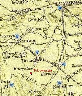
Lemberg
  aka
Lwow
  or L'viv


Rozdol

Stryj


Bolechow


Stanislawow

  Tysmienitca

[ Other Maps | Holocaust ]

The map on the left side is a tiny clip
of Galicia (1882), part of the
Austro-Hungarian Empire.
see Full map 238 Kb © 1996, FEEFHS

Scale:
map height is about 105 km (65 miles)
map width  is about  75 km (47 miles)


  • The Eastern area
  • The main area where Turkels were residing
  • ABC list of all shtetl's
    where Turk'l folks lived in

  • Information about the holocaust
    (will open a new window)

    Lwow     Sambor     Podwoloczyska     Tarnopol     Tarnow     Turka     Trembowla     Vienna


    Other Maps
    Displayed at a secondary window

    Austro-Hungarian Empire (1882): Galicia overview
  • Central area of Galicia (123 Kb)   23o- 26oE / 48o- 50oN
  • Full map (238 Kb)   19o- 27oE / 48o- 50o40'N     Source: FEEFHS Map Room at ucDavis
    © CopyRight 1996, FEEFHS - Federation of East European Family History Societies

  • Map of Poland (on this site) A larger beautiful map at The Perry-Castañeda Library at the Univ. of Texas at Austin
  • Map of Ukraine compressed version 36 Kb of © Magellan 66 Kb GIF see secondary window
  • Map of Europe

  • Sign or View guestbook  |  Web-Site Directory

    © 1998-2003 'Türkel Tribe'