Galicia -
The Eastern area where Turkels  settled in
|
The map on the right side is a tiny clip of Galicia (1882), part of the Austro-Hungarian Empire. See Full map 238 Kb © 1996, FEEFHS Close shtetl's outside this map: to the North to the South |
Mikulince Mikulintsy Buczacz Buchach |
Tarnopol
26oE Zbarasz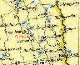 Scale: Chortkov map width is about 80 km (50 miles) map height is about 67 km (42 miles) [ Other Maps | Holocaust ] ABC list of shtetl's |
pic & about Podwoloczyska Skalat Grzymalov Trembowla near River Sered (center of map) Chorostkow Husiatin 49oN latitude |
Information about places (will open a new window)
Lwow in Holocaust Podwoloczyska Picture Sambor in Holocaust Tarnow in HolocaustTarnopol Turka Trembowla Vienna
Other names of Trembowla (Hungarian)
| German | Yiddish | Polish | Ukrainian |
| Terebowlja | טרעבעוולע | Trembowla | Теребовля |
About Tereblovlyia in Shtet Links at JewishGen.org
Photo of shtetl's synagogue taken June 2000 by Buz Hahn
Jews were residing there as early as the 17th century.
A snapshot of Trembowla History
The End of Trembowla Jews
Other Maps
Displayed at a secondary window
|
Austro-Hungarian Empire (1882): Galicia overview
© CopyRight 1996, FEEFHS - Federation of East European Family History Societies |
View guestbook | Web-Site Directory
© 1998-2003 'Türkel Tribe'